Overview
This document provides summary statistics combining the vegetation burned analysis from both the Eureka Fire and Black Rock Fire (January 2025) in Joshua Tree National Park.
Code
# Load vegetation burned summaries <- read_csv (file.path ("fires/eureka/outputs/veg_burned_summary.csv" ), show_col_types = FALSE ) |> mutate (fire = "Eureka" )<- read_csv (file.path ("fires/black_rock/outputs/veg_burned_summary.csv" ),show_col_types = FALSE ) |> mutate (fire = "Black Rock" )
Total Area Burned
Code
# Extract totals <- eureka_veg |> filter (MapUnit_Name == "Total Burned Area" ) |> pull (veg_ha)<- black_rock_veg |> filter (MapUnit_Name == "Total Burned Area" ) |> pull (veg_ha)<- eureka_total + black_rock_totaltibble (Fire = c ("Eureka" , "Black Rock" , "**Combined Total**" ),Hectares_Burned = c (eureka_total, black_rock_total, combined_total),Acres_Burned = c (eureka_total, black_rock_total, combined_total) * 2.471 ,Percent_of_Total = c (eureka_total/ combined_total * 100 , / combined_total * 100 , 100 )|> kable (digits = 1 , format.args = list (big.mark = "," ), col.names = c ("Fire" , "Hectares Burned" , "Acres Burned" , "Percent of Total" )) |> kable_styling (bootstrap_options = c ("striped" , "hover" ))
Eureka
87.2
215.4
73.1
Black Rock
32.1
79.2
26.9
**Combined Total**
119.2
294.6
100.0
Vegetation Types Burned
Combined Vegetation Summary
Code
# Combine vegetation data (excluding totals) <- bind_rows (eureka_veg, black_rock_veg) |> filter (MapUnit_Name != "Total Burned Area" ) |> group_by (MapUnit_Name) |> summarise (total_ha = sum (veg_ha),fires_affected = paste (unique (fire), collapse = ", " ),.groups = "drop" |> arrange (desc (total_ha)) |> mutate (pct_combined = total_ha / combined_total * 100 ,cumulative_pct = cumsum (pct_combined)|> select (Vegetation_Type = MapUnit_Name,Total_Ha = total_ha,Pct_of_Combined = pct_combined,Fires_Affected = fires_affected|> kable (digits = 2 , col.names = c ("Vegetation Type" , "Total Ha" , "% of Combined" , "Fires Affected" )) |> kable_styling (bootstrap_options = c ("striped" , "hover" )) |> scroll_box (height = "400px" )
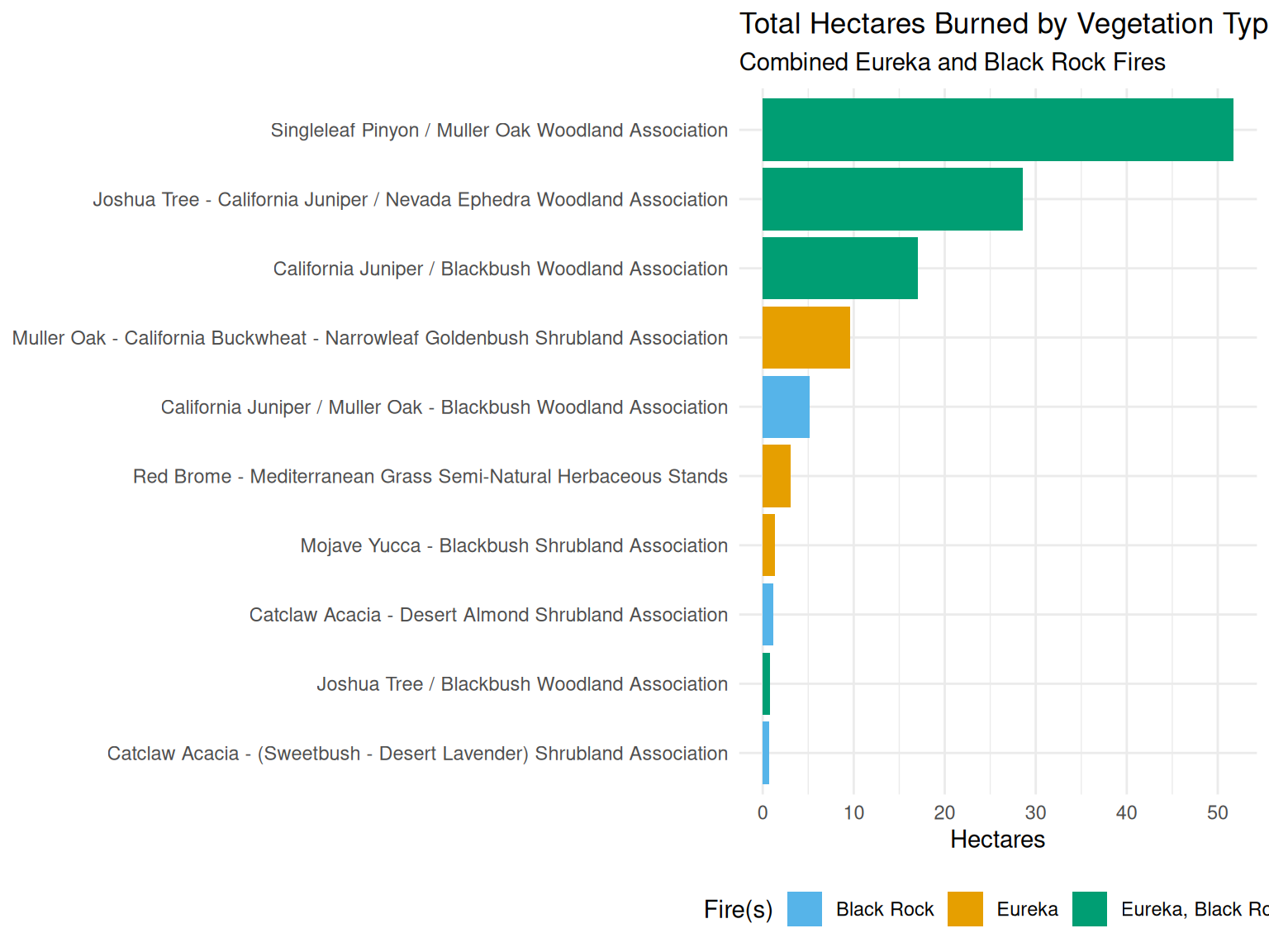
Singleleaf Pinyon / Muller Oak Woodland Association
51.72
43.38
Eureka, Black Rock
Joshua Tree - California Juniper / Nevada Ephedra Woodland Association
28.57
23.96
Eureka, Black Rock
California Juniper / Blackbush Woodland Association
17.02
14.27
Eureka, Black Rock
Muller Oak - California Buckwheat - Narrowleaf Goldenbush Shrubland Association
9.57
8.03
Eureka
California Juniper / Muller Oak - Blackbush Woodland Association
5.18
4.34
Black Rock
Red Brome - Mediterranean Grass Semi-Natural Herbaceous Stands
3.10
2.60
Eureka
Mojave Yucca - Blackbush Shrubland Association
1.34
1.13
Eureka
Catclaw Acacia - Desert Almond Shrubland Association
1.20
1.00
Black Rock
Joshua Tree / Blackbush Woodland Association
0.82
0.69
Eureka, Black Rock
Catclaw Acacia - (Sweetbush - Desert Lavender) Shrubland Association
0.72
0.60
Black Rock
Side-by-Side Comparison
Code
# Create comparison table <- union ($ MapUnit_Name,$ MapUnit_Name|> setdiff ("Total Burned Area" )<- tibble (MapUnit_Name = all_veg_types) |> left_join (|> select (MapUnit_Name, eureka_ha = veg_ha, eureka_pct = pct_of_total),by = "MapUnit_Name" |> left_join (|> select (MapUnit_Name, black_rock_ha = veg_ha, black_rock_pct = pct_of_total),by = "MapUnit_Name" |> replace_na (list (eureka_ha = 0 , eureka_pct = 0 , black_rock_ha = 0 , black_rock_pct = 0 )) |> mutate (total_ha = eureka_ha + black_rock_ha) |> arrange (desc (total_ha))|> select (Vegetation_Type = MapUnit_Name,Eureka_ha = eureka_ha,Eureka_pct = eureka_pct,Black_Rock_ha = black_rock_ha,Black_Rock_pct = black_rock_pct,Combined_ha = total_ha|> kable (digits = 2 , col.names = c ("Vegetation Type" , "Eureka (ha)" , "Eureka (%)" , "Black Rock (ha)" , "Black Rock (%)" , "Combined (ha)" )) |> kable_styling (bootstrap_options = c ("striped" , "hover" )) |> scroll_box (height = "400px" )
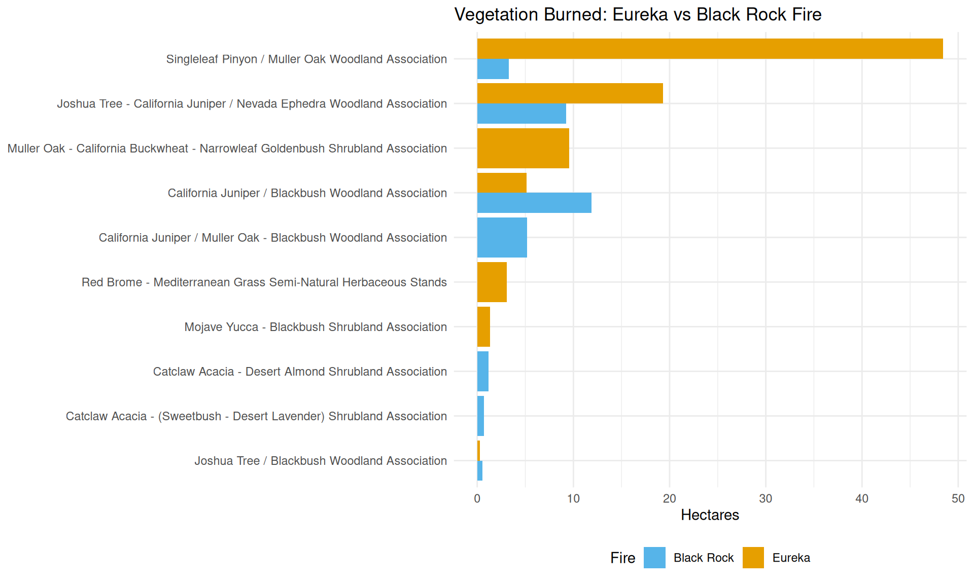
Singleleaf Pinyon / Muller Oak Woodland Association
48.45
55.59
3.27
10.20
51.72
Joshua Tree - California Juniper / Nevada Ephedra Woodland Association
19.31
22.16
9.25
28.86
28.57
California Juniper / Blackbush Woodland Association
5.12
5.87
11.90
37.11
17.02
Muller Oak - California Buckwheat - Narrowleaf Goldenbush Shrubland Association
9.57
10.98
0.00
0.00
9.57
California Juniper / Muller Oak - Blackbush Woodland Association
0.00
0.00
5.18
16.14
5.18
Red Brome - Mediterranean Grass Semi-Natural Herbaceous Stands
3.10
3.55
0.00
0.00
3.10
Mojave Yucca - Blackbush Shrubland Association
1.34
1.54
0.00
0.00
1.34
Catclaw Acacia - Desert Almond Shrubland Association
0.00
0.00
1.20
3.73
1.20
Joshua Tree / Blackbush Woodland Association
0.27
0.31
0.55
1.71
0.82
Catclaw Acacia - (Sweetbush - Desert Lavender) Shrubland Association
0.00
0.00
0.72
2.25
0.72
Visualizations
Area Burned by Fire
Code
|> ggplot (aes (x = reorder (MapUnit_Name, total_ha), y = total_ha, fill = fires_affected)) + geom_col () + coord_flip () + scale_fill_manual (values = c ("Eureka" = "#E69F00" , "Black Rock" = "#56B4E9" , "Eureka, Black Rock" = "#009E73" , "Black Rock, Eureka" = "#009E73" )) + labs (title = "Total Hectares Burned by Vegetation Type" ,subtitle = "Combined Eureka and Black Rock Fires" ,x = NULL ,y = "Hectares" ,fill = "Fire(s)" + theme_minimal () + theme (legend.position = "bottom" )
Fire Comparison
Code
bind_rows (eureka_veg, black_rock_veg) |> filter (MapUnit_Name != "Total Burned Area" ) |> ggplot (aes (x = reorder (MapUnit_Name, veg_ha), y = veg_ha, fill = fire)) + geom_col (position = "dodge" ) + coord_flip () + scale_fill_manual (values = c ("Eureka" = "#E69F00" , "Black Rock" = "#56B4E9" )) + labs (title = "Vegetation Burned: Eureka vs Black Rock Fire" ,x = NULL ,y = "Hectares" ,fill = "Fire" + theme_minimal () + theme (legend.position = "bottom" )
Key Statistics
Code
# Top vegetation types <- eureka_veg |> filter (MapUnit_Name != "Total Burned Area" ) |> slice_max (veg_ha, n = 1 )<- black_rock_veg |> filter (MapUnit_Name != "Total Burned Area" ) |> slice_max (veg_ha, n = 1 )<- combined_veg |> slice_max (total_ha, n = 1 )# Count unique veg types <- eureka_veg |> filter (MapUnit_Name != "Total Burned Area" ) |> nrow ()<- black_rock_veg |> filter (MapUnit_Name != "Total Burned Area" ) |> nrow ()<- nrow (combined_veg)
Summary
Total Combined Area Burned : 119.2 hectares (294.6 acres)Eureka Fire : 87.2 ha (73.1% of total)Black Rock Fire : 32.1 ha (26.9% of total)
Vegetation Types
Total Vegetation Types Affected : 10
Eureka Fire: 7 types
Black Rock Fire: 7 types
Top Vegetation Types by Fire
Eureka
Singleleaf Pinyon / Muller Oak Woodland Association
48.4
55.6%
Black Rock
California Juniper / Blackbush Woodland Association
11.9
37.1%
Combined
Singleleaf Pinyon / Muller Oak Woodland Association
51.7
43.4%
Report generated on 2025-12-04